
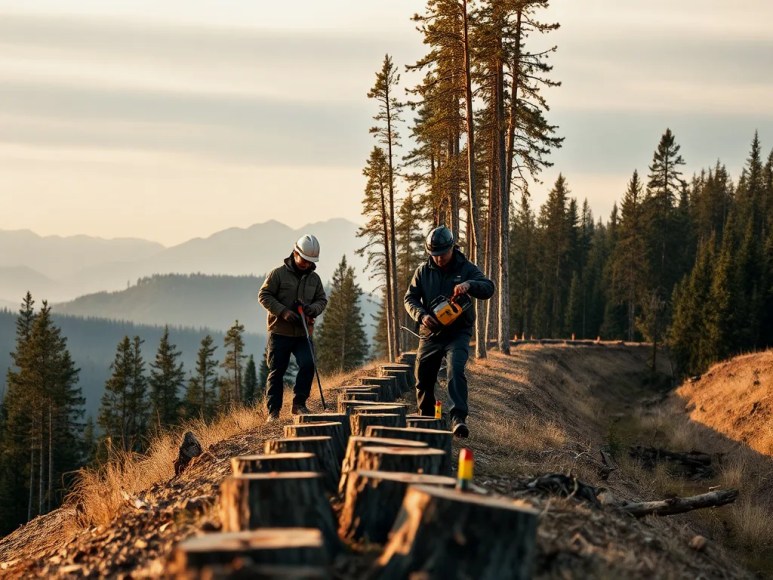
The visible line: what the cleared corridor is and where it runs
The border between the United States and Canada is the world’s longest uninterrupted land boundary at 8,891 kilometers. For thousands of kilometers where that line crosses continuous forest, authorities maintain a cleared corridor roughly 6 meters (about 20 feet) wide. The corridor removes trees and tall shrubs directly along the surveyed international boundary, producing a continuous, unambiguous strip that can be seen from the ground and from the air.
Why officials cut a continuous 6-meter gap through dense forest
Clearing a narrow, consistent corridor accomplishes several practical goals. First, it preserves a clear, permanent visual cue along a legally surveyed line, preventing accidental encroachment by people or machinery that might otherwise be confused about which side they occupy. Second, a maintained gap makes routine boundary inspections faster: surveyors and border maintenance crews can walk or drive along the cleared line to inspect markers, GPS coordinates and monuments without bushwhacking. Third, the absence of tall vegetation reduces the chance that trees will fall across the boundary and hide survey monuments or create jurisdictional disputes following storms.
Who manages and maintains the corridor
The International Boundary Commission (IBC), a binational agency created by treaty, is responsible for maintaining the cleared corridor in forested areas. The IBC schedules periodic maintenance—typically cyclical multiyear programs—during which crews clear new growth, remove fallen timber, and check survey monuments. Maintenance combines contract loggers, local crews, and IBC personnel; depending on the location, agencies coordinate with provincial, state, tribal and municipal authorities to gain access and minimize environmental impact.
How the corridor is created and kept clear: step-by-step process
Creating and maintaining the corridor follows a repeatable workflow that balances precision and practicality:
1) Survey and flag the exact boundary: Licensed surveyors use GPS, original treaty monuments and historical bearing data to place precise markers. Trees within the corridor are cataloged so endangered specimens can be noted for special handling.
2) Plan access and environmental protections: Crews map access roads, temporary staging areas and erosion controls. If wetlands, protected species or cultural sites are nearby, mitigation measures are implemented—seasonal timing, buffer zones or selective cutting instead of clear-felling.
3) Cut and remove trees: Teams cut trees and large shrubs within the 6-meter strip. Timber removal varies by contract: some projects chip brush and haul logs out, others windrow material to one side for burning or mulching, always following local regulations.
4) Inspect and record monuments: After clearing, surveyors inspect boundary monuments and record coordinates and photographs. Any displaced or damaged markers are repaired or reset promptly to preserve the legal line.
5) Schedule follow-up maintenance: The IBC or partner agencies set recurring maintenance intervals—commonly every few years—based on local vegetation growth rates and resource availability.
Environmental and community considerations
Maintaining a permanent cleared corridor through forest raises ecological and social questions. The IBC and partners use targeted practices to reduce ecological harm: selective trimming rather than broad clear-cutting near sensitive habitat, leaving snags for cavity-nesting birds where safe, and re-evaluating plans when rare species are detected. In populated areas, managers consult landowners, Indigenous groups, and recreational users to address concerns around access, aesthetics and cultural sites. In some locations, creative solutions such as narrower clearings or low-impact mechanical cutters are used to balance visibility with conservation.
Examples and data points that illustrate scale and outcomes
Across the full 8,891 km border, the cleared corridor is most visible in long forested stretches in Alaska–Yukon, northern British Columbia, and parts of the Great Lakes region. Although the corridor width is standardized at 6 meters in many areas, terrain and legal agreements can cause minor variations. Maintenance budgets and schedules differ by segment: remote areas often have longer intervals between work due to access costs, while corridors near roads and communities see more frequent upkeep.
Common questions people ask about the corridor (answered directly)
Does the clearing mean the border is militarized? No. The corridor is a maintenance and survey measure, not a security fortification. It exists to keep the legal boundary visible and to maintain survey markers, not to obstruct civilian movement on either side.
Does clearing harm wildlife? Clearing impacts a narrow strip of habitat but managers apply mitigation—timing of work, selective cutting, and retention of certain structural elements—to reduce harm. In many cases wildlife moves around the corridor; its narrow width limits landscape-scale fragmentation compared with broad-scale logging or road-building.
Could the corridor be removed or narrowed? Any change requires binational agreement through the IBC and would require new survey, environmental review, and possibly treaty-level consultation. Practicality and legal clarity typically favor maintaining the corridor.
What to watch for in future management
Climate-driven changes—longer growing seasons and more extreme storms—will influence maintenance frequency and methods. Remote sensing (satellite imagery and aerial lidar) is increasingly used to detect regrowth and locate fallen timber between on-the-ground visits, enabling more targeted crews and cost-effective maintenance. Advances in low-impact forestry equipment and stronger collaboration with Indigenous stewards also promise to reduce ecological trade-offs while preserving the border’s visibility.
Key takeaways
Maintaining a 6-meter cleared corridor through forested sections of the US–Canada border is a precise, practical practice designed to make a legally surveyed line unambiguous. The International Boundary Commission oversees careful, recurring work that balances accurate surveying, logistical access, and environmental mitigation. As budgets, technology and climate change reshape the landscape, the corridor’s management continues to adapt, using remote sensing and improved field techniques to keep the boundary clear with minimal harm.