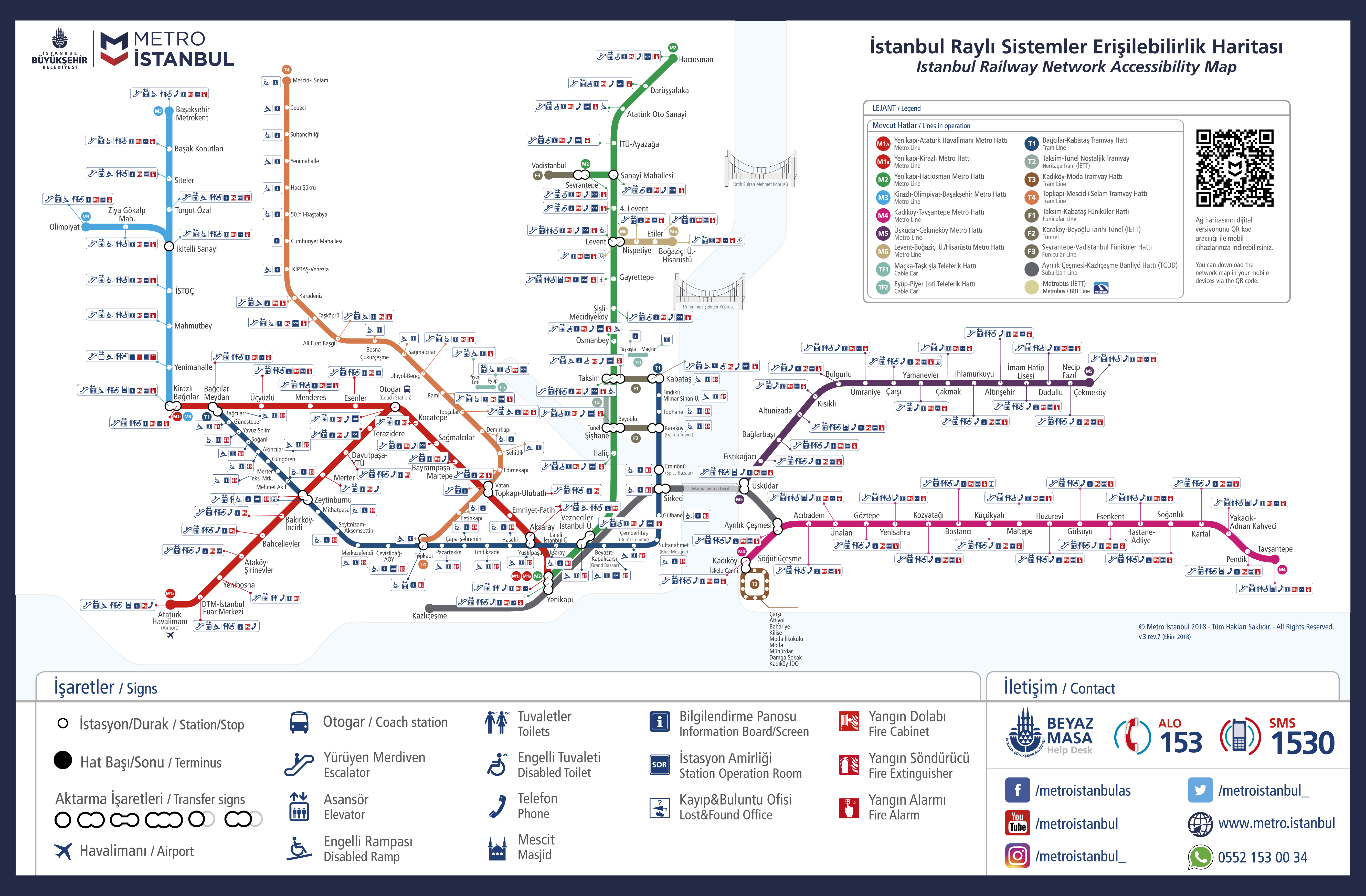
Istanbul Rail Systems Access Map: All details are shown on Istanbul Rail Systems Access Map, click on the map for a larger version of Istanbul Rail Systems Access Map. Maps are for information purposes, call the relevant institution for their original versions. Images of Istanbul Rail Systems Access Map are attached, click to enlarge. You can also download and print the original size Istanbul Rail Systems Access Map.

Istanbul Metro lines that will operate until 2019
- - Beylikdüzü TÜYAP - Bahçelievler - Kirazlı Metro Rail System: 2017
- - Bakırköy - İncirli - Bahçelievler - Kirazlı Subway Railway System: 2017
- - Halkalı - Olympic Stadium - Kayabaşı - Kayaşehir - 3. Airport Metro Rail System: 2019
- - Başakşehir - Kayaşehir - Kayabaşı Metro Rail System: 2018
- - Beşiktaş - Kabataş Metro Rail System: 2019
- - Beşiktaş - Mecidiyeköy Metro Rail System: 2019
- - 4. Levent - Hisarüstü Metro: 2015
- - Mecidiyekoy - Mahmutbey Metro: 2017
- - Incirli - Yenikapi Subway: 2018
- - Edirnekapı - Unkapanı Metro: 2018
- - Göztepe Bagdat street - Göztepe E5 - Ataşehir - Ümraniye subway station: 2018
- - Üsküdar - Taksim - Haliç - Çekmeköy metro: 2015
- - Çekmeköy - Sancaktepe - Sultanbeyli - Sabiha Göçmen Airport Metro: 2018
- - Bostancı - Kozyatağı - Kayışdağı - İmes - Dudullu Metro: 2019
- - Kartal - Pendik Metro: 2015
- - Pendik - Tuzla Metro: 2019
- - Kartal Beach - Pendik E5 - Sabiha Immigration Airport Metro: 2017
Within the scope of the new metro projects, Otogar - Kirazlı - Bağcılar - Başakşehir Metro was opened in June. Taksim - Golden Horn - Yenikapı Metro will be in service this year. In addition, under the Marmaray Yenikapı - Sirkeci - Üsküdar tunnel passage is opened this year.
Be the first to comment